


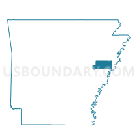
PARROT PCT 18, St. Francis County, Arkansas
About
Outline

Summary
| Unique Area Identifier | 527980 |
| Name | PARROT PCT 18 |
| County | St. Francis County |
| State | Arkansas |
| Area (square miles) | 12.26 |
| Land Area (square miles) | 11.90 |
| Water Area (square miles) | 0.35 |
| % of Land Area | 97.11 |
| % of Water Area | 2.89 |
| Latitude of the Internal Point | 35.07354300 |
| Longtitude of the Internal Point | -90.73507840 |
Maps


Graphs
Select a template below for downloading or customizing gragh for PARROT PCT 18, St. Francis County, Arkansas


Neighbors
Neighoring Voting District (by Name) Neighboring Voting District on the Map
- CALDWELL COUNTRY PCT 23, St. Francis County, AR
- COLT COUNTRY PCT 21, St. Francis County, AR
- MADISON TWP PCT 25, St. Francis County, AR
- NEWCASTLE PCT 19, St. Francis County, AR
Top 10 Neighboring County Subdivision (by Population) Neighboring County Subdivision on the Map
- Madison township, St. Francis County, AR (17,247)
- Telico township, St. Francis County, AR (2,125)
- Johnson township, St. Francis County, AR (2,121)